Project Description
As founding and active members of the Highway 89 Stewardship Team, and in collaboration with the State of Nevada Department of Wildlife (NDOW), DFG’s North Central Region wildlife biologists are using GPS and satellite radio collars to better understand the movements and habits of mule deer (Odocoileus hemionus hemionus) in the Loyalton-Truckee Deer Herd (LTH).
The biologists use ground darting to chemically immobilize deer. This method involves using a specialized dart gun and controlled drugs, for which biologists receive special training from DFG veterinarians. Road hunting or stalking on foot is used to get within fifty yards of a deer before darting. After the drugs take effect biologists are able to approach and restrain the animal.
Measurements and samples are taken while monitoring the health of the animal. The collar is carefully fitted around the neck of the deer. Two types of collars are used: 1. Global Positioning System (GPS) collars record several locations daily and are monitored via an airplane. 2. Satellite collars allow weekly monitoring of deer locations via download to a computer. The collar battery will last between ten and eighteen months after which the collar will fall off the animal and be recovered so that the data can be collected. Each waypoint from the collar will include the time, date, temperature and number of satellites used in the data collection. Biologists can then map the movement of the deer and associate it with weather conditions, habitat preferences and other factors.
Herd Information and Location
The LTH ranges over an area of approximately 1,240 square miles that includes five California counties (Lassen, Plumas, Sierra, Nevada, and Placer), and one Nevada county (Washoe) (DFG 1982). Two distinct sub-units were described in the 1982 DFG Deer Herd Management Plan: the Sierra Valley sub-unit (SVSU) representing the X7a premium deer zone and the Verdi sub-unit (VSU) or X7b.
The herd range is bounded on the north by Highway 70 and extends southwest from Portola over Beckworth Pass, along the crest of the Sierra Nevada south over Donner Pass to the Placer-El Dorado county line near Miller Lake then along McKinney Creek to the west shore of Lake Tahoe. In Nevada, deer winter on the south half of Petersen Mountain, the Sand Hills, Peavine Mountain near Verdi and south of the Truckee River on the north and west facing slopes of the Carson Range.
The LTH migrates between summer ranges primarily in California and winter ranges primarily in Nevada. The timing of migration movements is May-June and mid-October-November, depending on weather. Critical summer and winter ranges, fawning areas, transitional areas and migratory corridors have been and continue to be disrupted by fire, development, reduction in early seral stage habitat, and barriers such as roads and highways. Management decisions pertaining to hunting, development, mitigation, habitat connectivity and land acquisition must take these impacts into consideration and therefore rely on current and accurate information. Population for the LTH, including both sub-units, is stable to declining with an average, estimated size around 3,200 individuals. The California Department of Transportation (CalTrans) has recorded over 1,000 SVSU deer mortalities in an ongoing road-carcass database that began 27 years ago. Such impacts on the population can affect viability of the herd, particularly when combined with habitat loss and degradation.
Study Area
Within the SVSU collaring takes place on the Hallelujah Junction Wildlife Area and Antelope Valley Wildlife Area in Sierra County during winter or on the Tahoe National Forest on summer range. For the VSU efforts have been focused on summer and fall home ranges within the Martis Valley, primarily on the Truckee River Wildlife Area and surrounding conserved areas, or on private property of willing owners. Deer in the SVSU were first collared in 2006 and are part of the Highway 89 Stewardship Team’s long-term study plan. In the VSU, collaring efforts began in 2009 and are funded through 2013.
Highway 89 Stewardship Team
In 2003, the Highway 89 Stewardship Team (Team) was formed. The Team consists of agency biologists, educators, scientists and local community representatives from DFG, the United States Forest Service, CalTrans, the UC Cooperative Extension, UC Berkeley’s Sagehen Creek Field Station, the Sierra County Board of Supervisors, the Sierra County Fish and Game Commission and the California Deer Association. Team members are working together to proactively reduce deer and wildlife mortality on the 25-mile stretch of Highway 89 between Truckee and Sierraville in Nevada and Sierra counties through research, mitigation and outreach.
In 2006, using grant money from the Title III Resource Advisory Committee, the Team purchased ten GPS radio collars to place on female deer in the SVSU. There are now fifteen collars being monitored on the SVSU. Combined with CalTrans carcass data and photos from remote camera stations along the highway, the GPS data provides a representation of current use, timing, and movement habits of deer to help the Team select underpass locations. An underpass can come in any size and is a kind of tunnel or passage under a road that animals can safely use instead of trying to cross the road. After several years of pre-monitoring and data analysis, Kyburz Flat in Sierra County was selected as the spot for the first underpass.
Students from local Sierra County schools participated in numerous outreach and educational programs provided by the Team. These included:
- a field day at Sagehen Creek Field Station with biologists from each participating agency
- an in-class curriculum
- a summer work program where students collected data for the Team
- environmental projects in the community
- a logo contest
- the design of interpretive panels that will be placed along Highway 89
The Team has received annual grants from the California Deer Association to continue the collaring project as well as financial support from the Sierra County Fish and Game Commission and the Mule Deer Foundation. Strategic fencing with experimental design and wildlife jump-outs will be built in 2013 along both sides of Highway 89 surrounding the underpass. Cameras and collars will continue monitoring what should be an increase in the amount of wildlife using the crossing once the fence is in place. The Team will then focus on the next mitigation: a set of underpasses and fencing on Sagehen Grade.
The Interstate Partnership
For many years biologists from DFG and NDOW have met each year to share data and establish hunting quotas for the deer herds that spend time in both California and Nevada. Changes in population, catastrophic fires and other types of habitat loss, ratios of resident to migratory deer, and seasonal fluctuation in hunter success make it necessary to co-manage the deer that rely on both states. In 2009, the two agencies joined forces to get a better understanding of the VSU. Between fall of 2009 and summer 2011, twenty-seven deer were collared through financial support from The Martis Fund, the Truckee-Tahoe Aiport, the Mule Deer Foundation and dedicated funds from hunter license sales in both states, and in partnership with Save Open Space around Glenshire.
During 2010 DFG and NDOW biologists, along with members of NDOW’s Environmental Education program, created an in-class Adopt-A-Deer Herd project for sister schools in Glenshire, California and Verdi, Nevada. As part of the science rotation at both schools, 145 fourth and fifth grade students and teachers received lessons on deer biology, movements and local considerations for the management of the VSU. NDOW created a private website for the students to post “ask a biologist” questions and for teachers to download class activities as well as KMZ files of deer migration for use in Google Earth. Students monitored the movement of the deer via computer as they left winter range in Nevada and headed for summer range in California. The class work culminated in a joint field trip on buses paid for by Nevada Bighorns Unlimited. Students gathered on winter range as the NDOW helicopter flew in, saw demos of dart and net guns, demonstrated their newly acquired tracking skills on computers for the media, and played a predator/prey game of finding cover in the open sage brush. Then they combed through an area where some of the collared deer had wintered and received prizes furnished by Cabela’s, DFG’s Project WILD and the California Deer Association, for finding signs of deer. Some brought back pellets and others collected the sheds and bones that had been placed for them. Finally the group headed to summer range and participated in a telemetry exercise to find collars that had been hidden in the brush. Currently, a national curriculum is being developed to mirror this program with grant money furnished by The Martis Fund.
Project Summary
To date, 87 LTH mule deer have worn collars. Twenty-six of those from the SVSU have crossed Highway 89 and several from both sub-units have crossed Interstate 80 (I80). Migrations are very weather-dependent and vary from year to year. Paths average 26 miles between summer and winter and almost always follow the same trail in spring and fall. The longest migration was about 43 miles. A few of the collared deer have intermingled between the two sub-units demonstrating that geographic barriers are not completely separating the LTH. DFG’s Hallelujah Junction and Antelope Valley wildlife areas continue to be a huge resource for wintering deer while the Truckee River Wildlife Area in Nevada County is supporting a large number of VSU deer in the summer.
DFG will continue to partner with NDOW and play an active part in the Highway 89 Stewardship Team as we work to ensure that mule deer are a continued presence in the Sierra Nevada. Better understanding of the movement, habits, and biology of any species, along with connectivity across barriers, and sound management can help ensure that our wildlife remains viable for the enjoyment of all.
Photos and Maps
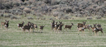 Mule Deer gathered on winter range in the Sierra Valley. DFG photo by Sara Holm.
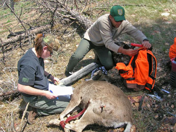 NCR wildlife biologists Sara Holm and Henry Lomeli start to process an immobilized deer on the Antelope Valley Wildlife Area. DFG photo by Paul Raquel.
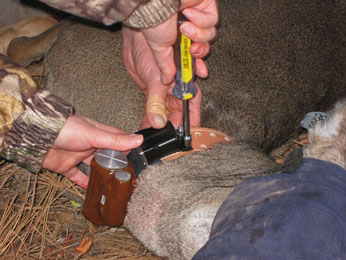 A female mule deer is fitted with a satellite collar. DFG photo by Josh Bush.
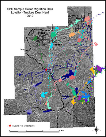 Click to view map: Migration path of several different mule deer from the LTH.
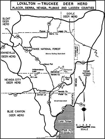 Click to view map: Loyalton-Truckee Deer Herd Boundary from the 1982 Management Plan.
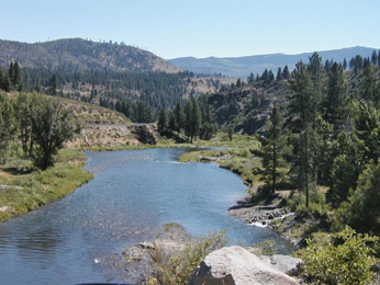 The Truckee River Wildlife Area is prime summer range habitat. The river and the interstate both divide the sub-units in the Loyalton-Truckee Deer Herd. DFG photo by Sara Holm.
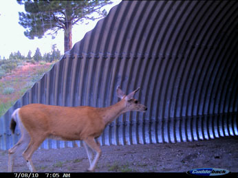 A deer from the LTH moves through the underpass built at Kyburz Flat. Highway 89 Stewardship Team photo.
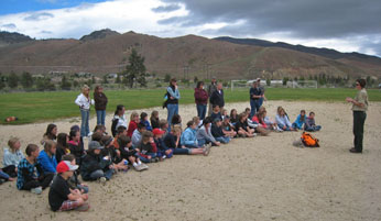 Students from Glenshire and Verdi Elementary Schools watch as Sara Holm prepares to demonstrate how the dart gun works. DFG photo by Josh Bush.
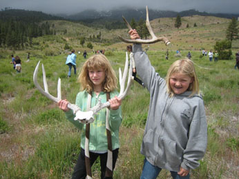 Two students display deer sheds they found on Nevada’s winter range. DFG photo by Sara Holm.
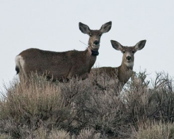 A collared deer using the Hallelujah Junction Wildlife Area. DFG photo by Jan Dawson.