Monitoring
Piloted Aerial Surveys
A detailed summary of kelp monitoring in California can be found in the Giant Kelp and Bull Kelp Enhanced Status Report(opens in new tab).
Historically, the California Department of Fish and Wildlife (CDFW) conducted coastwide (including the Channel Islands) aerial surveys of giant and bull kelp canopy. The first aerial survey was conducted in 1989, followed by a survey in 1999 and generally annual surveys from 2002 through 2016, although surveys were not completed by CDFW for some years and regions due to budget constraints, weather conditions, or equipment malfunction. Results of the CDFW aerial kelp surveys are depicted below. Geographic Information System shapefiles of the aerial kelp surveys(opens in new tab) can be found on the CDFW website as well as on MarineBIOS, a CDFW marine and coastal map viewer. Other piloted aerial kelp survey programs include MBC Aquatic Sciences’ Southern California Bight regional aerial kelp surveys(opens in new tab).
 California Department of Fish and Wildlife aerial kelp canopy survey results, 1989-2016. Surveys not conducted in all regions and years depicted as "ND". Regions: north coast (Oregon-California state line to San Francisco Bay), central coast (San Francisco Bay to Point Conception), and south coast (Point Conception to U.S.-Mexico border, including the Channel Islands). CDFW graphs
Satellite Remote Sensing
Recently, an important tool CDFW uses to monitor kelp canopy cover is satellite imagery. The graphs below depict combined giant and bull kelp canopy area as measured from Landsat satellite imagery and processed by the Santa Barbara Coastal Long-Term Ecological Research program(opens in new tab) (Santa Barbara Coastal LTER et al. 2022). These data are publicly available in an interactive map on the Kelpwatch.org(opens in new tab) web page.
 Kelp canopy area quarterly (grey) and annual maxima (black) from 1984 to the first quarter of 2022 in three regions: north coast (Oregon-California state line to San Francisco Bay), central coast (San Francisco Bay to Point Conception), and south coast (Point Conception to U.S.-Mexico border, including the Channel Islands) as estimated from processed satellite imagery (Santa Barbara Coastal LTER et al. 2022) summed in each region. Missing points indicate no data. Note the y-axis for the north coast is an order of magnitude smaller. CDFW graphs
References
Santa Barbara Coastal LTER; Bell, T.; Cavanaugh, K., and Siegel, D. (2022) SBC LTER: Time series of quarterly NetCDF files of kelp biomass in the canopy from Landsat 5, 7 and 8, since 1984 (ongoing) ver 13. Environmental Data Initiative. In: Environ. Data Initiat. https://doi.org/10.6073/pasta/93b47266b20bc1782c8df9c36169e372(opens in new tab). Accessed 02 May, 2022.
Unoccupied Aerial Systems Surveys
Unoccupied aerial systems (UAS, also known as drones) can be a high-resolution imaging method to estimate kelp canopy area. They can map kelp close to complex shorelines, distinguish between kelp species, target specific locations, and have significant flexibility to choose survey timing. UAS can provide essential information for monitoring kelp forest restoration and recovery due to their ability to detect sparse canopy at a local scale. Partner agencies and organizations including The Nature Conservancy, Greater Farallones National Marine Sanctuary(opens in new tab) and Greater Farallones Association have led efforts to utilize UAS to map sites off Sonoma and Mendocino counties’ coastlines, areas that have been highly impacted by kelp loss. These efforts have been successful in demonstrating the capabilities of UAS surveys as a tool to inform kelp canopy dynamics, recovery, and strategic restoration efforts at a local scale (Saccomanno et al. 2022(opens in new tab)).
 Scientists with the Kashia Band of Pomo Indians and scientists with the Greater Farallones Association preparing for a UAS (drone) flight survey to map kelp canopy on the Kashia Coastal Reserve in Sonoma County. CDFW photo by K. Elsmore
References
Saccomanno, V.R.; Bell, T.; Pawlak, C.; Stanley, C.K.; Cavanaugh, K.C.; Hohman, R.; Klausmeyer, K.R.; Cavanaugh, K.; Nickels, A.; Hewerdine, W.; Garza, C.; Fleener, G., and Gleason, M. (2022), Using unoccupied aerial vehicles to map and monitor changes in emergent kelp canopy after an ecological regime shift. Remote Sens Ecol Conserv. https://doi.org/10.1002/rse2.295(opens in new tab)
Subtidal Monitoring
Subtidal monitoring of kelp forests using SCUBA divers has occurred for several decades and provides critical information that cannot be obtained through aerial methods, including kelp density and community diversity. However, this method is much more limited in spatial and temporal scale.
There are several subtidal monitoring programs collecting long-term data in kelp forest ecosystems throughout the state, including CDFW’s north coast (Mendocino and Sonoma counties) nearshore ecosystem dive surveys (est. 1971). Other important subtidal monitoring programs include Partnership for Interdisciplinary Studies of Coastal Oceans(opens in new tab) (PISCO; est. 1999), Channel Islands National Park Kelp Forest Monitoring Program(opens in new tab) (KFM; est. 1982), and Reef Check California(opens in new tab) (RCCA; 2005-present). An interactive map showing the monitoring sites of many of these groups can be found on the Sanctuary Integrated Monitoring Network(opens in new tab) (SIMoN)’s Kelp Ecosystem Monitoring Map(opens in new tab). Additionally, marine protected area (MPA) monitoring provides baseline and long-term monitoring of kelp forest ecosystems(opens in new tab). Refer to the MPA Monitoring Program web page for more information.
 and giant kelp (L)") Left: Juvenile bull kelp (Nereocystis luetkeana) encountered during surveys at Timber Cove, Sonoma County. Right: Juvenile giant kelp (Macrocystis pyrifera) at Tanker Reef, Monterey County. CDFW photos by K. Elsmore
Left: Juvenile bull kelp (Nereocystis luetkeana) encountered during surveys at Timber Cove, Sonoma County. Right: Juvenile giant kelp (Macrocystis pyrifera) at Tanker Reef, Monterey County. CDFW photos by K. Elsmore
Restoration
Kelp forest restoration has been practiced in California since at least the 1960s, with most historical efforts occurring in Southern California. Projects have included outplanting kelp, transplanting reproductive material, providing substrate, removing urchins, and removing competitive and invasive algae. More details can be found in the Giant Kelp and Bull Kelp Enhanced Status Report(opens in new tab).
Some restoration initiatives include:
 Left: Purple urchins (Strongylocentrotus purpuratus) consume kelp (Pterygophora californica) in Monterey Bay. Right: Purple urchin (Strongylocentrotus purpuratus) on a coralline algae-covered rock in Monterey Bay. CDFW photos by K. Elsmore
Research
Kelp research is performed throughout California by academic researchers, state agencies, government agencies, non-governmental organizations, and more. A summary of kelp research in California can be found in the Giant Kelp and Bull Kelp Enhanced Status Report(opens in new tab).
The California Cooperative Oceanic Fisheries Investigations (CalCOFI) is a cooperative research program between government and academic organizations including CDFW, the National Oceanic and Atmospheric Administration, and Scripps Institution of Oceanography. CalCOFI studies the physics, biogeochemistry, and biology of the marine environment off the coast of California with a goal of informing the sustainable management of marine resources in the context of climate change. Visit the CalCOFI website(opens in new tab) to view reports on marine algae including the fishery in Volumes 42, 43, 51, and 55.
In 2020, California Sea Grant and the California Ocean Protection Council, in close partnership with CDFW, funded six actionable kelp recovery research projects to fill critical knowledge gaps in the efficacy of kelp restoration strategies. Learn more about the Kelp Recovery Research Program(opens in new tab) on the California Sea Grant website(opens in new tab).
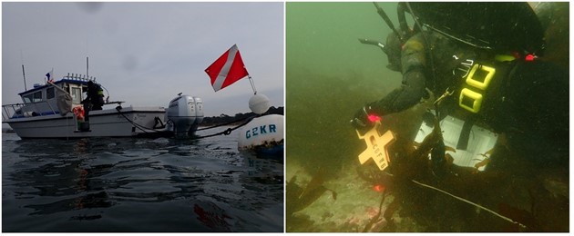 Left: CDFW diver aboard CDFW's R/V Mystinus, gearing up for a dive to assess recreational urchin removal efforts at Tanker Reef, Monterey Bay. Right: CDFW diver reels out transect tape to conduct subtidal kelp forest monitoring. CDFW photos by K. Elsmore