Science Spotlight

rss
  • October 12, 2018

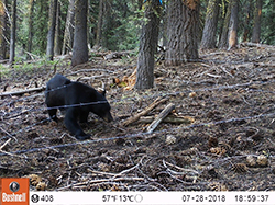
Trail cam photo of black bear in wooded area approaching barbed wire fence
Researchers built 90 hair-snare stations designed to pull a small hair sample from black bears that cross the snares.
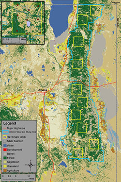
Map with legend
The Warner Mountains Black Bear Project study area (blue boundary) and layout of hair-snare grids (yellow squares) in northeastern California. The upper-left inset shows the southernmost hair snare grid and layout of hair-snare locations (red circles). Density estimates and information on habitat from within the 10 grids will help researchers estimate overall black bear abundance across the entire study area.

California’s black bear population is healthy and growing, with an estimated 35,000 animals, up from an estimated 10,000 to 15,000 in 1982. But how do wildlife biologists determine these figures – and why are they important?

Deep in the Warner Mountains in Lassen and Modoc counties CDFW is just completing the first year of a study of black bears. The lead scientist, Steffen Peterson, explained that anecdotal evidence in recent years – including increased bear sightings by both field scientists and everyday citizens, as well as an increased number of requests for depredation permits due to bear-human conflicts – seemed to indicate that the population of black bears in the Warner Mountains was booming and this area would be ideal for scientific research.

According to Peterson, the two primary objectives of the Warner Mountains Black Bear Project are to estimate black bear abundance in the study area and to determine how black bears use the landscape. This kind of information on black bear demography and space use is essential for wildlife managers to make scientifically sound bear management decisions for this region of California.

CDFW is using a genetic capture-recapture method to estimate the population size. Usually, this involves physically capturing an animal, marking it in some way and releasing it. But this particular study achieves the same goal with non-invasive techniques – specifically by using hair snares, which cause relatively little stress or harm to the animals. Hair snares have been used on many furbearing species to determine presence, to calculate a minimum absolute count of individuals present, or to estimate total population size by collecting a DNA sample from individuals without physically capturing the animal. Unique repetitive sequences, known as microsatellites, within the DNA sample serve as individual identifiers, making it possible to know when and where each unique animal was present.

In addition, because the DNA located within roots of mammalian hair can identify species, sex, and individuality, this genetic technique is ideal for researchers to estimate abundance as well as obtain information on demographics and genetic diversity.

Peterson, a CDFW scientific aid and a Humboldt State University graduate student, and other researchers built 90 hair-snare stations distributed across 10 sampling grids that that are designed to pull a small hair sample from bears that cross the snares.

The contraption consists of two parallel strands of barbed wire stretched around a cluster of three or more trees, one about eight inches off the ground and the other about 20 inches off the ground. This forms a barbed-wire “corral” in which researchers place a pile of logs drizzled with fish oil. The oil acts as an attractant to black bears, who have both a finely attuned sense of smell and a profound love of fish. At two thirds of the hair-snare stations, researchers placed a trail-camera to help verify the effectiveness of the snares at capturing hair samples when a bear is present. The trail photos also provide demographic (cub-adult ratio) information on bears within the study area.

“The use of hair-snares to collect genetic data for abundance and density estimates has become the gold standard for American black bear,” said Peterson. “The hope is for the bear to cross between the two strands of barbed wire, although some of our video footage from the trail cameras shows bears crossing – even jumping, in some cases –  over the wire. Because bears are big, robust animals, for the most part they pay little mind to the barbs and typically cross them, leaving us a nice big clump of hair. Bears are the ideal critter for hair-snares in this way.”

Although Peterson stressed that it is much too soon in the study process to draw conclusions about the number of black bears living on the grid, initial results indicate that, at a bare minimum, black bears are certainly roaming throughout the study area.

During a 50-day hair collection period that took place this summer, black bears were detected in all of the grids created in the study area that encompasses roughly 600 square miles of high desert terrain; researchers collected 469 samples of hair in all at 57 of the 90 hair-snare locations.

“Long story short, we are pleased by the amount of detections observed during our data collection,” Peterson said. “Good detections will strengthen our ability to estimate density within each grid which will allow us to more reliably estimate abundance off the grid – i.e., the Warner Mountain study area as a whole.”

Peterson is now set to begin the DNA analysis phase on the samples collected. This will allow him to determine precisely how many individual bears left hair behind (bears often leave more than one sample at a snare location and some individuals are repeat visitors), as well as information on gender and habitat use, including the movement of bears across the study area.

Next summer, project staff will capture and collar 12 adult black bear with research collars, which will record hourly GPS locations of the bears as they move across the landscape, providing information on how they use the landscape, including seasonal habitat preferences and, during the winter hibernation period, where bears den.

“This information will greatly improve our knowledge of how bears use these high desert ecosystems, characteristic of the Great Basin, and guide future land management in this region,” Peterson said.

The project is expected to continue for another two to three years. ###

CDFW Photos. Top Photo: Emily Monfort, a CDFW scientific aid, carefully removes black bear hair from barbed wire at a hair-snare location. The DNA from this clump of hair will be examined in the laboratory to determine the sex and genetic identity of the black bear that crossed this wire.  Photo credit Korrina Domingo (CDFW).

Categories: Wildlife Research
  • July 24, 2018

Frog resting on rock
Yellow-Legged Frog

Small river pool of water featuring a small waterfall trees, rocks and steep, rocky terrain
Mountain Yellow-Legged Frog habitat

Many years of painstaking monitoring and assessment efforts undertaken by CDFW have helped guide an ongoing effort to bolster the dwindling populations of mountain yellow-legged frogs in Southern California.

Tim Hovey, a senior environmental scientist in CDFW’s South Coast Region, has been hiking through the forest to monitor and evaluate yellow-legged frogs in Little Rock Creek and Big Rock Creek in the Angeles National Forest since 2002, when they were listed under the Endangered Species Act (they were listed as state endangered in 2013). At that time, it was estimated that fewer than 100 adult frogs remained in the wild. 

The drastic decline of this population over the last 50 years has been a cause for concern to biologists. “The mountain yellow-legged frog is a critical part of the fragile stream ecosystem here in Southern California,” Hovey explains. “We hope that our efforts to increase the wild population through captive tadpole release will eventually lead to self-sustaining populations that will no longer require captive care to recover.”  

Hovey estimates that fewer than 400 adult mountain yellow-legged frogs currently exist in the wild in small populations throughout its range in Southern California. Threats to the species include habitat loss, pollution, non-native predators and the deadly amphibian disease chytridiomycosis, which is caused by the chytrid fungus. Some measures have already been taken to help the species. From 2002 to 2012, for example, CDFW was the lead agency involved in removing non-native predatory fish in a section of Little Rock Creek, located below the current mountain yellow-legged frog population, which essentially doubled the amount of high-quality habitat available for frogs in the stream.

But more human intervention is necessary, in the form of captive rearing. The multi-pronged effort to bolster mountain yellow-legged frogs includes contributions from the U.S. Fish and Wildlife Service, the Los Angeles Zoo, San Diego Zoo Global, the U.S. Forest Service, the U.S. Geological Survey (USGS), and others.

According to Hovey, the captive rearing project began in 2014, when wild-caught tadpoles were removed from Little Rock Creek and Big Rock Creek by USGS staff during a breeding cycle. The tadpoles were raised to adulthood in captivity at the Los Angeles Zoo in temperature-controlled aquaria in a quiet frog-rearing room, carefully equipped to mimic the frogs’ natural life cycle conditions.

While the tadpoles were growing, CDFW staff conducted field surveys to evaluate suitable habitat, using the data to identify specific streams where mountain yellow-legged frogs could potentially be released. The criteria for evaluation considered current recreational uses, access for monitoring, safety and property ownership. The resulting list of approved locations was reviewed by the other agencies and is being used to guide the releases.

On June 26, 500 tadpoles, descendants of the captive Big Rock Creek frogs, were released back into their historic range in the lower section of Big Rock Creek in the Angeles National Forest. Another 500 tadpoles, offspring of the Little Rock Creek captive group, were released on June 27 into Devils Canyon Creek in the Angeles National Forest. The offspring of the captive frogs, which were bred and kept separate, were released into their creeks of origin.  

“These releases represent a promising first step in the recovery of mountain yellow-legged frogs, as well as hopefully establishing new populations in areas where the frog has been absent for over fifty years,” Hovey said.  “We hope that with continued agency coordination and continued tadpole releases, the dwindling numbers of these endangered frogs will slowly begin to rebound and recover.”

This was the first release of tadpoles into Angeles National Forest with several more scheduled this summer throughout portions of the species’ range. 

###

CDFW Photos courtesy of Tim Hovey. Top Photo: Mountain Yellow-Legged Frog.

For more information:

US Fish and Wildlife Service, “Trailblazing Tadpoles
US Fish and Wildlife Service, Draft Recovery Plan for the Mountain Yellow-Legged Frog
CDFW, Mountain Yellow-Legged Frog, description and taxonomy
 

Categories: General
  • July 5, 2018

The California Department of Fish and Wildlife (CDFW) has completed its 2018 waterfowl breeding population survey -- and it’s good news for hunters and birdwatchers alike, as the total waterfowl population in the state now tops out at over a half million, for the first time in six years.

Melanie Weaver, who oversees CDFW’s Waterfowl Program, said that duck populations responded positively to the wet winter conditions of 2017. “Given the good upland and wetland habitat conditions last year from excessive precipitation, we anticipated good production,” she said. “We are pleased to see that higher recruitment reflected in this year’s breeding population survey.”

The full Breeding Population Survey Report, which can be found on the CDFW website, indicates the 2018 breeding population of mallards increased from 198,392 in 2017 to 272,859 (an increase of 38 percent). Mallards are the most abundant waterfowl species in the state, followed by gadwall (102,637) and cinnamon teal (78,498).

Other ducks that increased in number include northern shovelers, wood ducks, redhead and canvasback. Overall, the total number of ducks increased from 396,529 to 549,180 (an increase of 39 percent).

A few duck species did decline, including American wigeon, northern pintail, lesser scaup, ring-necked duck, ruddy duck and common merganser. But Weaver gave two possible explanations for these dips. First, none of these species are considered “strong nesters” in California. They migrate through the state, but don’t breed here in high numbers. And second, the survey is designed for dabbling ducks, meaning that diving ducks (such as mergansers) are harder for biologists to detect.

The survey also included Canada geese, which dropped slightly in number, from 55,224 in 2017 to 54,851 this year. (Canada geese are detected and recorded throughout the survey; however, the number reported refers to the traditional nesting population in northeastern California.)

CDFW biologists and warden pilots have conducted this survey annually using fixed-wing aircraft since 1948. The population estimates are for those areas where the vast majority of waterfowl nesting occurs in California, including wetland and agricultural areas in northeastern California, throughout the Central Valley, the Suisun Marsh and some coastal valleys.

In 2018, the survey was flown April 24-28 in the Central Valley and May 9-10 in northeastern California. A few planned survey segments were cancelled due to weather conditions (fog in the Napa-Santa Rosa area, and high winds in a few planned transects in the northeastern part of the state). However, the crew was able to cover 97 percent of the planned survey transects.

The majority of California’s wintering duck population originates from breeding areas surveyed by the U.S. Fish and Wildlife Service (USFWS) in Alaska and Canada. Those survey results should be available in early August. CDFW survey information, along with similar data from other Pacific Flyway states, is used by the USFWS and the Pacific Flyway Council when setting hunting regulations for the Pacific Flyway states, including California.

CDFW Photo

###

Media Contacts:
Melanie Weaver, CDFW Wildlife Branch, (916) 445-3717
Kirsten Macintyre, CDFW Communications, (916) 322-8988
 

Categories: Wildlife Research
  • June 11, 2018

Man holding large cardboard box in front of man holding turkey.
Tim Hermansen of CDFW carries a turkey holding box to CDFW’s Levi Sousa while John Davis clears the net.

Person holding turkey while another person holds turkey foot against wooden post.
Derek Schiewek of CDFW holds a turkey while CDFW’s Laura Cockrell measures the tarsus.

Recent efforts to determine the number of turkeys on the Upper Butte Wildlife Area have been a net success.

CDFW staff and volunteers from the National Wild Turkey Federation (NWTF) began annual turkey banding efforts in 2015 to gather information about turkey demographics and movements to facilitate better management of the population and assess future hunting opportunities. Approximately a dozen volunteers and staff have since worked on this effort two months each year, in the late winter through early spring.

Captured birds are fitted with a numbered band, and their age, gender and weight are determined before they are released. The number of times a turkey is recaptured through ongoing trapping activities, or when a hunter returns a band to CDFW, provides data about the density and the movements of the birds. Approximately 20 wild turkeys have been captured each of the past four years, using air cannons that propel nets. Last year was the sole exception, as torrential storms resulted in zero captures because portions of the property were flooded and could not be traversed with trapping equipment.

“That year was very frustrating, but part of being a wildlife biologist is going with the flow,” recalled CDFW Environmental Scientist Laura Cockrell, who is involved in coordinating and facilitating wildlife surveys on the wildlife area.

This year, walk-in traps were used for the first time to supplement the traditional use of air cannons, and the final tally was 38 turkeys banded, increasing the total number banded over the course of the project to 88. This baseline data will inform decisions on how many turkey hunters will be allowed access to the wildlife area each spring.

“Our volunteers and all our staff are what makes this project successful,” Cockrell said. “Everyone completes a safety training so we can make sure the birds are handled quickly and carefully, and then it is a lot of ‘hurry up and wait’ during the trapping operations. If we did not have a dedicated crew on this project, it would not be successful. The walk-in traps allow staff to set up trapping operations in the morning, check the site throughout the day, and process birds as they are captured.”

Also appreciative of the banding efforts were turkey hunters, who had an extra “spring” in their step this year at the Upper Butte Wildlife Area.

The 2018 spring turkey hunts recently ended after 64 hunters who hunted on Upper Butte Basin harvested 35 turkeys. During the previous three spring seasons combined since spring turkey hunts began on the wildlife area in 2015, 133 hunters participated and 47 turkeys were harvested.

All the result of field conversations between CDFW staff and fall turkey hunters.

“During the fall turkey seasons some years back, hunters at the check stations would frequently ask us when we were going to offer a spring season, which we had not done before,” Cockrell said.

At the wildlife area’s Howard Slough and Little Dry Creek units, the problem was not a lack of turkeys but rather a lack of funding to hire staff to advertise, prepare, regulate and operate the extra hunts – and a lack of scientific data to support an extra hunting season.

A collaborative effort between CDFW and the NWTF solved that problem.

In 2014, NWTF applied for and received a state grant from the Upland Game Bird Stamp Fund. The grant proposal, which was spearheaded by NWTF District Biologist Kevin Vella, obtained five years of funding to support a seasonal coordinator position.

“This spring we had almost 1,800 applications for 144 open spots,” said Cockrell. “Our hunters really appreciate the opportunities that the spring turkey hunts provide. We frequently hear after a hunt what an amazing time they had out in the field and how much they enjoyed their time on the wildlife area. One of our hunters this season was so excited because he was able to harvest a nice turkey at his very first hunt!”

All photos © National Wild Turkey Federation, all rights reserved. Top Photo: Tim Hermansen of CDFW holds a turkey while Laura Cockrell of CDFW measures its beard with calipers.

Categories: General
  • April 12, 2018

CDFW wants to know if, when and where you’ve seen an elk in California – and they’ve just created a new online reporting tool that makes it easy for members of the public to share this information.

CDFW scientists will use the raw data to help guide their efforts to study statewide elk distribution, migration patterns and herd movement, population size estimates, habitat use, health and diseases, and causes of mortality.

“We have limited resources and our scientists cannot scan the entire landscape,” explained CDFW Senior Environmental Scientist Pete Figura. “This tool provides a way for us to leverage the many sightings of the wildlife-watching public. People often get excited when they see elk, and hopefully now they will channel that excitement by reporting the location and time of their sighting to our department.”

There are three subspecies of elk in the state – tule, Rocky Mountain and Roosevelt -- and all three have expanded their range in recent years according to Figura.

CDFW has elk studies underway in the northern part of the state: one is focused on Roosevelt elk in Humboldt and Del Norte counties, and the other is focused on elk in Siskiyou and Modoc counties. Tracking and studying such a large mammal is a complex undertaking as elk herds are wide-ranging, and often graze and browse in areas that are not easily accessible, and there are only so many scientists to monitor their movements.

The launch of the reporting tool is just the latest effort to enhance the management of elk in California. Last year CDFW released a public draft of the Statewide Elk Conservation and Management Plan that addresses historical and current geographic range, habitat conditions and trends, and major factors affecting elk in California.

The plan will provide guidance and direction for setting priorities for elk management efforts statewide. CDFW is reviewing public comments on the plan and will incorporate appropriate changes into the final document prior to its release, which is expected soon.

CDFW Wildlife Branch Chief Kari Lewis has termed the plan an “important milestone” and explained that public feedback is a critical part of shaping the effort, which emphasizes a sharing of resources and collaboration with all parties interested in elk and elk management. This, she said, is essential to effectively managing California’s elk populations.

For more information about elk in California, please visit CDFW’s elk management webpage.

CDFW File Photo. Top photo: Group of Tule Elk.

# # #

Categories: General
CDFW Science Institute logo

Subscribe

Receive Science Institute news by email.