Science Spotlight

rss
  • February 23, 2018

Grass and shrub-covered dunes next to estuary waters, under a cloudy sky
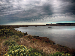
Restoration project area. CDFW photo by Andrew Hughan.

Map with orange and yellow areas to be restored, between Humboldt Bay and the Eel River
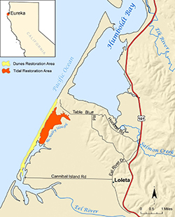
Yellow and orange indicate restoration areas at the Ocean Ranch Unit of CDFW's Eel River Wildlife Area.

How does one best go about making an already bountiful and bucolic part of the Golden State even better? Sometimes, perhaps paradoxically, it pays to look to the past in order to be forward thinking in the present.

CDFW, Ducks Unlimited, and many partners have undertaken the Ocean Ranch Unit of the Eel River Wildlife Area Integrative Ecosystem Restoration Project Planning Process to enhance the estuarine and coastal dune ecosystem of the Ocean Ranch Unit in Humboldt County

The approximately 2,600-acre Eel River Wildlife Area was acquired to protect and enhance coastal wetland habitat, and was designated as a wildlife area by the California Fish and Game Commission in 1968. The initial decision to undertake an estuary restoration-planning project began more than a decade ago. After several years of monitoring to gather necessary data, Ducks Unlimited completed a feasibility study, funded by CDFW’s Fisheries Restoration Grant Program and the California State Coastal Conservancy, in December 2015.

The primary goal is to restore and expand natural estuarine and dune ecosystem functions, including the recovery and enhancement of native species (including fish, invertebrates, wildlife and plants) and their habitats. These changes should also help mitigate current and future impacts of climate change. Sea level rise will likely result in saltwater inundation further upstream, which is expected to modify habitats (for example, the loss of tidal marsh migration inland) and the size and shape of the estuary.

The project has been a revelation for Michelle Gilroy, a CDFW district fisheries biologist who works primarily in Humboldt and Del Norte counties.

“For the first time in my 30-year fisheries career, which began in the Eel River watershed, I am achieving a long-time goal of mine: To envision, develop and work through to completion, or near completion, a large restoration project,” said Gilroy. “This exciting project and the extraordinary team I am so very fortunate to work with is making that dream a reality – and in the Eel River estuary, one of California’s largest estuaries. It is definitely one of the highlights of my career.”

Improving the connectivity of tidal and freshwater habitats, and controlling or eradicating invasive plants, are key goals of the restoration project.

A feasibility study guiding the project analyzed the potential for expanding tidal functions within 475 of the 933 acres of the unit to aide in the recovery and enhancement of estuarine habitat and native species. Restoration of these essential habitats is vital to the recovery of anadromous salmonid populations in the Eel River, as estuaries provide critical nursery and rearing conditions for juveniles prior to ocean entry.

The unit is located within the Eel River estuary, a mile and a half north of the mouth of the Eel River and approximately four miles northwest of Loleta. The unit is comprised of a diverse set of habitats, including coastal dunes, riparian woodlands, tidal mudflats, tidal slough channels, salt marshes and managed freshwater marshes.

Prior to second-wave human settlements, this portion of the estuary, then inhabited by Native Americans, consisted primarily of salt-marsh habitat dotted with areas of spruce and hardwood forest, and native grasslands. An abundant fishery, which included the prized salmon, along with native plants, provided sustenance for the Wiyot people who lived around Humboldt Bay and the estuary. As Euro-Americans settled this region, however, they largely drove the Wiyot people off their traditional lands and began to repurpose portions of the environment.

By the end of the 1800s, most of the salt marsh and forestlands were drained and converted to farm and grazing land. This conversion of tidal marshes to pastures was done with purpose – but such perceived progress carried an ecological cost.

The construction of levees and tide gates to drain salt marsh increased sedimentation, flooding, and the amount and diversity of habitat and food supply for fish and wildlife declined throughout the estuary. This degraded the prior functioning, highly productive estuary ecosystem. In addition, invasive species now threaten the diversity or abundance of native species through competition for resources, predation, parasitism, interbreeding with native populations, transmitting diseases, or causing physical or chemical changes to the invaded habitat.

Despite these declines, the Eel River delta, which includes the Eel River Wildlife Area, today continues to provide vital habitat for many aquatic and terrestrial organisms, including state and federally threatened and endangered fish, wildlife and plant species, and many state species of special concern. More than 40 species of mammals and 200 species of birds use the delta area and researchers have documented at least 45 fish species in the Eel River estuary alone.

The area provides essential spawning, nursery and feeding grounds to several commercially and recreationally important species, including Dungeness crab. Estuaries are among the most productive and diverse ecosystems in the world and are one of the preferred habitats for young Dungeness crabs.

Dungeness crabs use estuaries as critical nursery habitat in their juvenile stages, as not only a refuge from predation – particularly in estuaries with structural habitat such as eelgrass – but also because of the abundance and diversity of prey provided by estuaries. Dungeness crabs are opportunistic feeders – clams, fish, isopods and amphipods are their preferred food sources, as well as other Dungeness crabs. Their predators include those larger crabs, octopuses, and fish, including salmon, lingcod and various rockfishes.

Wildlife, of course, is not the only form of life to reap the benefits of this region, as humans enjoy a range of outdoor activities, including fishing, bird-watching, boating, hiking and hunting.

The project is expected to begin in the summer of 2019.

CDFW photos and map

Top photo: CDFW Senior Environmental Scientist Kirsten Ramey and Eric Ojerholm of the Pacific States Marine Fisheries Commission.


Partners, Funding and Staff

Ducks Unlimited, in partnership with CDFW staff, has recently secured project planning funds from the California Wildlife Conservation Board, and initial project implementation funds from the NOAA Restoration Center. To complete the restoration design and environmental compliance process, this second phase of restoration planning will consist of a continued CDFW and Ducks Unlimited partnership, with additional assistance from several local consultants and a Technical Advisory Committee (TAC). The TAC includes representatives from the U.S. Army Corps of Engineers, the Bureau of Land Management, U.S. Fish and Wildlife Service, National Marine Fisheries Service, California Coastal Commission, California State Coastal Conservancy, North Coast Regional Water Quality Control Board, California Sea Grant, California Trout, Humboldt County Resource Conservation District, Humboldt State University, Redwood Region Audubon Society, private landowners, and the Wiyot Tribe. Additional project partners include AmeriCorps, Tom Origer and Associates, Pacific Coast Fish, Wildlife and Wetlands Restoration Association, GHD Inc., H.T. Harvey and Associates, Moffatt and Nichol, Northern Hydrology Engineering, Pacific Coast Joint Venture, and the Pacific States Marine Fisheries Commission.

CDFW staff who have served on the project management team include Michelle Gilroy, Allan Renger, Scott Monday, Kirsten Ramey, James Ray, Mark Smelser, Gordon Leppig, Michael van Hattem, Jennifer Olson, Linda Miller, Clare Golec, Charles Bartolotta, Robert Sullivan, Tony LaBanca, Mark Wheetley, Scott Downie, Adam Frimodig, Jeff Dayton, Mike Wallace, Vicki Frey, John Mello, and Karen Kovacs.


Categories: General
  • January 30, 2018

The latest issue of California Fish and Game, 103-3, makes a significant contribution to the body of research related to longfin smelt in California. A paper titled, “link opens in new windowHistoric and contemporary distribution of Longfin Smelt (Spirinchus thaleichthys) along the California coast (PDF)” analyzes and presents observation data for this species from a variety of published and unpublished sources dating from 1889 to 2016. This anadromous fish, which is listed as threatened under the California Endangered Species Act, has been documented in a diverse range of habitats, including coastal lagoons, bays, estuaries, sloughs, tidal freshwater streams and nearshore habitats. In addition to providing a comprehensive look at the existing information available for longfin smelt along the California coast, this paper identifies additional information needed to improve management and enhance recovery of the species within the state.

In “link opens in new windowDistribution and derivation of dabbling duck harvests in the Pacific Flyway (PDF),” the authors look at abundance, banding and harvest data from throughout the Pacific Flyway and other important source areas in the Central Flyway to estimate the distribution and derivation of Pacific Flyway dabbling duck harvests during 1966−2013. The Pacific Flyway has long been considered an important wintering area for dabbling ducks. Better knowledge of the origins of these birds could assist in both harvest and habitat management.

The authors of “link opens in new windowDistribution of Amargosa River pupfish (Cyprinodon nevadensis amargosae) in Death Valley National Park, CA (PDF)” endured harsh environmental conditions to document the occurrence of Amargosa River pupfish along the lower Amargosa River drainage where the species has not been previously documented. The downstream-most location of Amargosa pupfish captured in this study extends the previously recorded geographic range approximately 49 river km. The findings not only determine the distribution of Amargosa River pupfish within Death Valley National Park, but will help identify suitable locations at which to establish long-term monitoring sites.

California Fish and Game has published high-quality, peer-reviewed science for the past 103 years, making important contributions to the understanding and conservation of California’s wildlife.

Cover photo courtesy of Gerald and Buff Corsi © California Academy of Sciences.

Categories: California Fish and Game Journal
  • January 19, 2018

An audio recording device in a semi-clear, plastic container on dark brown ground
The automated recorder model the scientists used. (CDFW photo by Brett Furnas)

Two avian researchers recently completed a groundbreaking study on the effects of climate change, based on the calls of California’s songbirds. By recording the sounds made by eight different songbird species, and tracking the dates they are most vocal and how frequently they sing, the scientists were able to develop a method to measure how the birds are adjusting to climate change.

CDFW Wildlife Ecologist Dr. Brett Furnas and William Jessup University’s Professor Michael McGrann analyzed data from two bird surveys, one done by CDFW and another led by William Jessup University, in the Klamath Mountains and Southern Cascades of northern California. Both studies used automated recorders to monitor bird sounds between 2009 and 2011. The results of their analysis, detailed in a research article entitled Using Occupancy Modeling to Monitor Dates of Peak Vocal Activity for Passerines in California, were published this month in a peer-reviewed, international journal of ornithology, The Condor: Ornithological Applications.

Furnas and McGrann’s study was prompted by the scientists’ concern that climate change could throw bird’s reproduction cycles out of sync with the seasons. Their work, which represents the first comprehensive assessment of songbird occupancy over approximately 15,000 square miles in California, earned high praise from Steve Beissinger, an expert on avian phenology at the University of California, Berkeley.

“Furnas and McGrann provide a textbook example of how to detect differences in the timing of nesting among bird species using information on the peak date of singing derived from surveys and automated recorders,” Beissinger said. “Their results support recent findings of a five-to-twelve day shift forward in the timing of peak singing by California birds in the nearby Sierra Nevada and coastal ranges in response to climate change.”

Because birds’ songs are correlated with their breeding behavior and are easily identifiable to species, the scientists found them to be a useful tool to provide new baseline data for the birds of northern California. Working together, they identified the precise dates of peak vocal activity for eight songbird species: Hutton’s vireo, hermit thrush, dark-eyed junco, Nashville warbler, MacGillivray’s warbler, yellow warbler, western tanager and black-headed grosbeak. In addition to gathering baseline data, Furnas and McGrann developed a method to track advances in the timing of vocal activity in the coming decades.

Male songbirds sing for several reasons -- including to advertise their territory or to find a mate with which to breed. When birds are at their most vocal, they are usually near the height of their breeding season, Furnas explained.

Much like the call of the imperiled “canary in the coal mine,” changes in the frequency or timing of these native birdsongs can serve as barometers of the cumulative impact of climate change.

“When the canary starts singing you know that there is a danger, such as a buildup of dangerous gasses in a mine,” Furnas explained. “When the birds in our study start singing earlier in the season, they are warning us that climate change is starting to disrupt complex ecological cycles that developed slowly over millions of years of evolution.”

One of the most interesting findings of the study so far is a hint in the baseline data that migratory birds may be at greater risk than non-migratory birds. “We found the highest singing activity for migrant birds spanned a shorter number of days than the highest singing activity for non-migratory birds,” Furnas said. “This could be because migratory birds have less flexibility to shift the timing of their breeding cycle. If they are prompted by increasing temperatures to migrate earlier in the year, they may arrive at their breeding grounds to find they don’t have enough insects to eat.

“Migratory birds have to compress a lot of activities into a shorter time period with less margin for error,” Furnas explained. “Think of it like scheduling a short holiday somewhere nice, but when you show up, bad weather cancels out a lot of your itinerary.”

This, in turn, negatively affects the very biodiversity that CDFW is responsible for monitoring.

“If all the species adjusted their ecologies similarly, perhaps that would be OK, but unfortunately, we expect that different insects and birds will react in different ways leading to a mismatch of conditions,” Furnas said.

Both CDFW and William Jessup University plan to continue bird surveys over the long term so that California has the information to support effective management of climate change and other conservation challenges.

Top photo: Singing hermit warbler, one of the species addressed in the study. (CDFW photo by Michael McGrann)

Categories: Wildlife Research
  • January 9, 2018

Seven adults carry pet carrier boxes across a coastal meadow
Staff of several wildlife agencies carry light-footed Ridgway’s rails (previously known as light-footed clapper rails) to Batiquitos Lagoon Ecological Reserve.

A man holds a bird with a long beak, while another attaches a band to its leg
A light-footed Ridgway’s rail is banded before release into Batiquitos Lagoon Ecological Reserve.

The Ridgway’s rail is a grayish-brown, chicken-sized bird with a long, downward curving bill and a conspicuous whitish rump. Previously known as the clapper rail, the species name was changed in 2014 to honor ornithologist Robert Ridgway. Three subspecies of Ridgway’s rail are resident in California, all of which depend on mudflats or very shallow water (wetland habitat) where there is both forage and taller plant material to provide cover at high tide. They rely on marsh plants such as cordgrass and pickleweed for breeding and feeding.

One subspecies, the light-footed Ridgway’s rail, was once abundant in the Southern California wetlands, but fell to near extinction in the 1980s as their historical habitats were displaced by housing developments. Today, they have a chance to repopulate, buoyed by recent wetland restoration projects by the California Department of Fish and Wildlife (CDFW) and “Team Rail,” a group that has been dedicated to the recovery of this federal- and state-listed marsh bird for more than a decade.

Team Rail is comprised of scientific staff from CDFW, the U.S. Fish and Wildlife Service (USFWS), the U.S. Navy, three zoological breeding centers (SeaWorld San Diego, the San Diego Zoo Safari Park, and the Living Coast Discovery Center) and the Huntington Beach Wetlands Conservancy. Thanks to their efforts, the 2017 rail population reached 514 pairs in the wild. Each rail release is a step closer to achieving the 1985 Light-Footed Clapper Rail Recovery Plan objective of having 800 breeding pairs in California.

Most recently, five light-footed Ridgway’s rails were released into the Batiquitos Lagoon Ecological Reserve in San Diego County. This release consisted of two mated pairs and three offspring produced by one of the pairs. Three of the adults are retired breeders from the zoological breeding program and are part of a rotation plan to reintroduce retired breeders back into the wild. The release of these individuals will contribute genetic diversity to this highly endangered marsh bird population. Rails bred in zoological facilities were released into Batiquitos Lagoon in 2004 and 2005 (eight rails each year), in 2013 (six rails), 2014 (12 rails), and 2015 (seven rails).

“Given that State Ecological Reserves are set aside for the conservation of threatened, rare and endangered species, and rail releases are targeted for wetlands with small subpopulations (fewer than 50 breeding pairs), Batiquitos Lagoon is an ideal location for the release of Ridgway’s rails,” explained CDFW Senior Environmental Scientist (Specialist) Nancy Frost. “For over a decade, CDFW has supported numerous research and monitoring projects for this species, and we are proud to be a partner in their recovery.”

The state-owned Batiquitos Lagoon is managed by CDFW and is one of the few remaining tidal wetlands on the Southern California coast. Located in the city of Carlsbad, it consists of 543 acres with a drainage basin of about 55,000 acres. It is home to several threatened and endangered birds, insects, plants, fish and mammals and is also designated as a State Marine Conservation Area under the Marine Life Protection Act.

Top photo: A light-footed Ridgway’s rail flies away after being released at Batiquitos Lagoon Ecological Reserve in San Diego County.

Categories: General
  • December 12, 2017

a brown frog looks up from green water and grass at the endge of a pond
A California red-legged frog sits motionless at the edge of McClure pond at the Sparling Ranch Conservation Bank. Photo by Ashley Spratt/USFWS

a small stand of oak trees is reflected in the green water of a pond, surrounded by dead, yellow grassy hillsides
McClure pond is one of the most productive California red-legged frog ponds at the Sparling Ranch Conservation Bank. Like many of those on Sparling Ranch, it was named after the family who homesteaded in site in the late 1800s. Photo by Ashley Spratt/USFWS

Since the mid-1980s, California has been using a system of conservation and mitigation banking to protect valuable natural resources and critical habitat for fish, wildlife and plants. These banks are generally large, connected, ecologically meaningful areas of preserved, restored, enhanced or constructed habitat (for example, wetlands) that are set aside for the express purpose of providing mitigation for project impacts. Conservation banks provide mitigation for impacts to listed species and habitats, while wetland mitigation banks primarily provide mitigation for wetland impacts. Together, they serve to prevent inadequate, fragmented reserves that can result when mitigation projects are carried out individually.

Banks work by establishing credits for sensitive species or habitats found on a given site. These credits can then be sold to developers or other project proponents who need to meet permitting requirements or are otherwise required to compensate for environmental impacts. For those parties needing to mitigate for project impacts, banks serve to streamline the regulatory process by providing a pre-established mitigation site that the regulating state and federal agencies have already confirmed will provide adequate and appropriate mitigation for certain habitats or species. By mitigating at a bank, project proponents can avoid the time and cost of searching for a suitable mitigation site and protecting it in perpetuity themselves.

In order for the banking system to be effective, state and federal agencies must work closely together to align processes and practices. Since 1993, CDFW has been participating in the planning, review, approval, establishment, monitoring and oversight of 81 banks statewide. Other agencies that typically participate in the regulation and approval of conservation banks include the U.S. Army Corps of Engineers (USACE), U.S. Environmental Protection Agency (USEPA), Natural Resources Conservation Service (NRCS), U.S. Fish and Wildlife Service (USFWS) and the National Oceanic and Atmospheric Administration National Marine Fisheries Service (NOAA NMFS).

To read more about one of these successful partnerships, link opens in new windowplease visit USFWS’ newsroom.

Learn more about CDFW’s Conservation and Mitigation Banking program, on our website.

All photos courtesy of U.S. Fish and Wildlife Service.

Top photo: A herd of cattle graze atop a hillside at Sparling Ranch near Hollister, Calif. Photo by Ashley Spratt/USFWS.

Categories: General
CDFW Science Institute logo

Subscribe

Receive Science Institute news by email.