Overview
In January 2024, the Cowcod Conservation Areas (CCAs) in California's Southern Management Area were repealed and replaced with Groundfish Exclusion Areas (GEAs). This repeal and replacement occurred through Amendment 32 of the Pacific Coast Groundfish Fishery Management Plan. These eight new Groundfish Exclusion Areas (GEAs) became effective January 1, 2024.
The CCAs were implemented in 2001 to reduce the bycatch of overfished cowcod, which was declared rebuilt in 2019. Amendment 32 removes the CCA restrictions for all recreational groundfish fisheries and non-trawl commercial groundfish fisheries, opening up approximately 4,663 sq mi (12,077 sq km) to these sectors. The CCAs remain in place for groundfish trawl fisheries, which were not changed by Amendment 32.
Groundfish Exclusion Areas
GEAs are a new type of Groundfish Conservation Area. GEAs are intended to mitigate potential impacts to sensitive deep water coral habitat, and prohibit all commercial and recreational groundfish fishing activity. If fishing for non-groundfish species within the GEAs, no groundfish are allowed on board the vessel. Commercial fishing vessels are allowed to continually transit through GEAs provided that all gear is stowed. Recreational vessels are allowed to continually transit through GEAs provided that no gear is deployed.
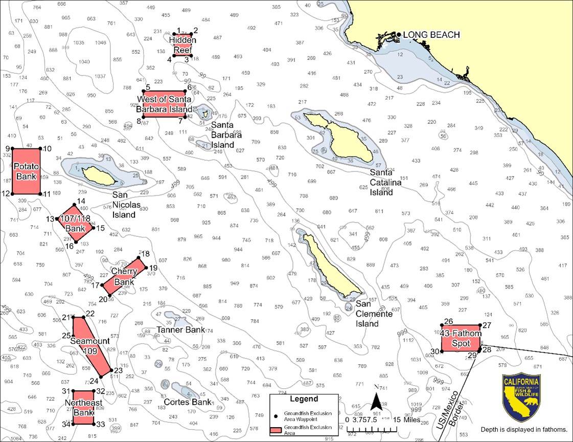
Map of GEAs
Click image below to open file in a new tab.
GEA Definitions
Groundfish Exclusion Areas (per 50 CFR 660.70(t)) are eight areas south of Point Conception intended to protect sensitive habitat areas, including areas where coral and sea pens are found. All eight GEAs can be viewed on CDFW's Ocean Sportfishing Interactive Map and GEA coordinates can be downloaded from NOAA's West Coast Groundfish Closed Areas web page.
The GEAs are defined as ocean waters off Southern California within each of the following eight areas (coordinate points listed below are displayed in map above):
The Hidden Reef GEA is defined by the straight lines connecting the following specific latitude and longitude coordinates in the order listed and connecting back to 33°46.14′ N lat., 119°10.45′ W long.:
1. 33°46.14′ N lat., 119°10.45′ W long.;
2. 33°46.14′ N lat., 119°05.96′ W long.;
3. 33°41.40′ N lat., 119°05.96′ W long.; and
4. 33°41.40′ N lat., 119°10.45′ W long.
The West of Santa Barbara Island GEA is defined by the straight lines connecting the following specific latitude and longitude coordinates in the order listed and connecting back to 33°33.64′ N lat., 119°18.54′ W long.:
5. 33°33.64′ N lat., 119°18.54′ W long.;
6. 33°33.64′ N lat., 119°07.57′ W long.;
7. 33°27.90′ N lat., 119°07.57′ W long; and
8. 33°27.90′ N lat., 119°18.54′ W long.
The Potato Bank GEA is defined by the straight lines connecting the following specific latitude and longitude coordinates in the order listed and connecting back to 33°21.00′ N lat., 119°53.00′ W long.:
9. 33°21.00′ N lat., 119°53.00′ W long.;
10. 33°21.00′ N lat., 119°45.67′ W long.;
11. 33°11.00′ N lat., 119°45.67′ W long.; and
12. 33°11.00′ N lat., 119°53.00′ W long.
The 107/118 Bank GEA is defined by the straight lines connecting the following specific latitude and longitude coordinates in the order listed and connecting back to 33°05.51′ N lat., 119°41.29′ W long.:
13. 33°05.51′ N lat., 119°41.29′ W long.;
14. 33°08.64′ N lat., 119°36.71′ W long.;
15. 33°03.50′ N lat., 119°31.69′ W long.; and
16. 33°00.36′ N lat., 119°36.27′ W long.
The Cherry Bank GEA is defined by the straight lines connecting the following specific latitude and longitude coordinates in the order listed and connecting back to 32°50.86′ N lat., 119°29.40′ W long.:
17. 32°50.86′ N lat., 119°29.40′ W long.;
18. 32°56.96′ N lat., 119°19.82′ W long.;
19. 32°54.69′ N lat., 119°17.78′ W long.; and
20. 32°48.59′ N lat., 119°27.35′ W long.
The Seamount 109 GEA is defined by the straight lines connecting the following specific latitude and longitude coordinates in the order listed and connecting back to 32°43.75′ N lat., 119°37.00′ W long.:
21. 32°43.75′ N lat., 119°37.00′ W long.;
22. 32°43.75′ N lat., 119°34.29′ W long.;
23. 32°31.95′ N lat., 119°26.94′ W long.;
24. 32°30.47′ N lat., 119°29.71′ W long.; and
25. 32°39.54′ N lat., 119°37.00′ W long.
The 43-Fathom Spot GEA is defined by the straight lines connecting the following specific latitude and longitude coordinates in the order listed and connecting back to 32°42.00′ N lat., 118°00.05′ W long.:
26. 32°42.00′ N lat., 118°00.05′ W long.;
27. 32°42.00′ N lat., 117°50.00′ W long.;
28. 32°36.70′ N lat., 117°50.00′ W long.;
29. 32°36.18′ N lat., 117°50.27′ W long.; and
30. 32°36.18′ N lat., 118°00.05′ W long.
The Northeast Bank GEA is defined by the straight lines connecting the following specific latitude and longitude coordinates in the order listed and connecting back to 32°27.39′ N lat., 119°37.00′ W long.:
31. 32°27.39′ N lat., 119°37.00′ W long.;
32. 32°27.39′ N lat., 119°31.60′ W long.;
33. 32°20.00′ N lat., 119°31.60′ W long.; and
32°20.00′ N lat., 119°37.00′ W long.
GEA Regulations
In summary, the GEAs prohibit recreational and non-trawl commercial fishing for groundfish. It is unlawful to take, retain, or possess groundfish inside a GEA, except for the purpose of continuous transit with all gear stowed. Fishing for non-groundfish species within a GEA is permitted, provided no groundfish are aboard the vessel. Visit CDFW’s Summary of Recreational Groundfish Fishing Regulations page for up to date regulations.