Overview
The Marine Invasive Species Program (MISP) is responsible for analysis of shipping vectors (pathways) responsible for the introduction of non-indigenous species (NIS) into California's coastal waters. MISP has partnered with the Smithsonian Environmental Research Center (SERC) and Moss Landing Marine Laboratories (MLML) to undertake an extensive program to analyze spatial and temporal patterns of NIS invasions in marine and estuarine waters of California.
Goals
The overall goals are to:
- Measure status and trends of biological invasions in coastal marine ecosystems of California;
- Understand geographic distribution, habitat distribution, and patterns of spread for non-native marine and estuarine species in California;
- Evaluate the vectors of introduction and spread of NIS in California;
- Detect changes in the patterns (rate, spread, prevalence) of NIS in response to shipping management regulations.
Approach
Our approach combines a statistically robust sampling design with two complementary methods of species identification:
- Morphological Analysis: Traditional taxonomic identification based on physical characteristics; and
- Molecular Genetic Analysis: Next-generation DNA sequencing.
Dr. Greg Ruiz from SERC collects paired samples; one set for morphological analysis by a taxonomist and another for molecular genetic analysis. He places PVC plates at designated sampling locations for organisms to settle on. After 3 months, settling plates are collected and taken to the lab, where live organisms are identified. Some specimens are sent to specialized taxonomists for identification.
Dr. Jon Geller from MLML conducts the molecular genetic analysis, specifically next-generation sequencing. Next-generation sequencing corroborates individual vouchers specimen identification and detects possible cryptic species among vouchers from plate samples. Next-generation sequencing also allows us to sample multiple, unsorted, whole communities (metagenetics), and then identify the individual species collected in the samples. Millions of individual DNA sequences can be analyzed during a single sample event. Each unique species that is genetically identified has a DNA barcode that is added to the DNA Reference Library, eventually reducing turn-around time and sampling cost.
Sampling Locations and Schedule
Bays and Estuaries
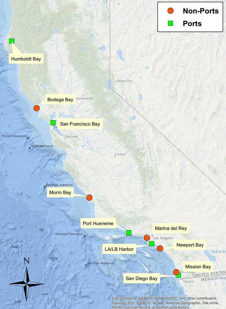
Current monitoring focuses on ten bays and estuaries:
- Humboldt Bay
- Bodega Bay
- San Francisco Bay
- Morro Bay
- Port Hueneme
- Marina del Rey
- Los Angeles/Long Beach Harbor
- Newport Bay
- Mission Bay
- San Diego Bay
The estuaries we selected for sampling include five with commercial ports and five without commercial ports, allowing a comparison of the two types of estuaries. The timeline includes sampling of sessile, plankton, and soft sediment communities in all ten bays and estuaries over seven years.
| BAYS & HARBORS
|
Sessile (Subtidal Hard Substrate)
|
Plankton
|
Soft Sediment (Subtidal)
|
| YEAR
|
12
|
13
|
14
|
15
|
16
|
17
|
18
|
19
|
12
|
13
|
14
|
15
|
16
|
17
|
18
|
19
|
12
|
13
|
14
|
15
|
16
|
17
|
18
|
19
|
| Humboldt Bay
|
|
|
|
x
|
|
|
|
x
|
|
|
|
x
|
|
|
|
x
|
|
|
|
x
|
|
|
|
|
| Bodega Bay/Tomales Bay
|
x
|
|
|
|
|
|
x
|
|
|
|
x
|
|
|
|
x
|
|
|
|
|
|
|
|
|
|
| Morro Bay
|
|
x
|
|
|
|
|
|
|
|
x
|
|
|
|
|
|
|
|
|
|
|
|
|
|
|
| Port Hueneme
|
|
|
|
x
|
|
|
|
|
|
|
|
x
|
|
|
|
|
|
|
|
|
|
|
x
|
|
| Marina del Rey Harbor
|
|
|
|
x
|
|
|
|
|
|
|
|
x
|
|
|
|
|
|
|
|
|
|
|
|
|
| Los Angeles Harbor / San Pedro
|
|
|
|
|
|
x
|
x
|
|
|
|
|
x
|
|
|
x
|
|
|
|
|
|
|
x
|
|
|
| Newport Bay
|
|
|
|
|
|
|
x
|
|
|
|
|
x
|
|
|
x
|
|
|
|
|
|
|
|
|
|
| Mission Bay
|
|
x
|
|
|
|
|
x
|
|
|
x
|
|
|
|
|
x
|
|
|
|
|
|
|
|
|
|
| San Diego Bay
|
|
x
|
|
|
|
|
x
|
|
|
x
|
|
|
|
|
x
|
|
|
x
|
|
|
|
|
|
|
| San Francisco Bay
|
x
|
x
|
x
|
x
|
x
|
x
|
x
|
|
|
x
|
x
|
x
|
x
|
x
|
x
|
|
x
|
x
|
x
|
x
|
x
|
x
|
x
|
|
Outer Coast
We completed a pilot monitoring program of the outer coast in areas adjacent to bays, estuaries, and harbors to examine the potential colonization by NIS. We did this by conducting intertidal and subtidal surveys to detect the presence of the bryozoan Watersipora spp. Watersipora spp. are easy to identify in the field and known to be present on the outer coast, therefore, surveys focused on this species provide a useful model to understand invasion dynamics and spillover of NIS from estuaries. The list of target species will be expanded for future outer coast monitoring.
| OUTER COAST
|
Rocky Intertidal Sites
|
Subtidal Sites
|
| YEAR
|
12
|
13
|
14
|
15
|
16
|
17
|
18
|
19
|
12
|
13
|
14
|
15
|
16
|
17
|
18
|
19
|
| Marin County
|
|
|
x
|
|
|
|
x
|
|
|
|
x
|
|
|
|
|
|
| San Mateo County
|
|
|
x
|
|
|
|
|
|
|
|
|
|
|
|
|
|
| Santa Cruz County
|
|
|
x
|
|
|
|
|
|
|
|
|
|
|
|
|
|
| Monterey County
|
|
|
x
|
|
|
|
|
|
|
|
x
|
|
|
|
x
|
|
Objectives
The objectives of this monitoring program are to:
- Distinguish native and non-native species of coastal waters of California.
- Test for differences in NIS diversity across different habitats.
- Estimate total NIS species diversity across estuaries.
- Test efficacy of ballast water control methods by establishing a baseline for free-swimming plankton, and monitor plankton for new invasions.
- Continue developing our DNA barcode library for NIS.