Inland Deserts Region (Region 6)
Riverside County
17050 Davis Road, Lakeview, California 92567
(Approximately 25 miles from Riverside)
Hours: Open daily, 7 a.m. to sunset.
Directions: From Riverside, take U.S. 215 to Ramona Expressway, east for about 8.5 miles to Davis Road. The checking station is on Davis Road 2.25 miles north of Ramona Expressway. There is no access to Davis Road from the north.
Note: During and after heavy rains, Davis Road can be very muddy and slippery and may be impassible. Call the Wildlife Area in advance for current road conditions.
Wildlife Area Contact: (951) 928-0580
Inland Deserts Region Bermuda Dunes Office: (760) 200-9158
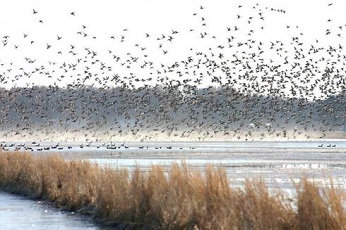
San Jacinto Wildlife Area is approximately 19,000 acres, with 900 acres of restored wetlands. It is the first state wildlife area to utilize reclaimed water to enhance its wetlands. Improvements are ongoing. Waterfowl, wading birds, and quail are a few of the many animals found here.
Notice: Please be advised that during rainy periods the auto tour road may be closed due to unsafe conditions. We recommend calling ahead to check conditions.
Entry Passes
A CDFW Lands Pass must be in possession of anyone 16 years of age or older while visiting San Jacinto Wildlife Area.
Visitors who are in possession of a valid California hunting or fishing license in their name are not required to purchase a Lands Pass, but this is true only for the license holder. Visitors age 16 or older accompanying the license holder must either show a valid California hunting or fishing license of their own, or a valid Lands Pass while visiting San Jacinto Wildlife Area.
Lands Passes may be purchased online, by phone at (800) 565-1458, or in-person at locations wherever hunting and fishing licenses are sold. A Lands Pass cannot be substituted for a Hunting Pass, which is required for adult hunters on Type-A wildlife areas.
A tour by an organized youth or school group is exempt from the Lands Pass requirement. Contact the Wildlife Area at (951) 928-0580 to schedule a field trip at least two weeks in advance.
Facilities
The primary staffed location on this property is the Headquarters Office, off Davis Road, just past the main gate. The Headquarters Office is open Monday through Friday from 7 a.m. to 3 p.m. The office is closed on all State and federal holidays.
Access roads, designated parking lots, restroom facilities, numerous hunting blinds and a viewing platform are all feature improvements on this land. During rainy periods, roads may be closed due to unsafe conditions. Call the Wildlife Area at (951) 928-0580 for current conditions.
The surrounding lands are primarily agricultural, principally dry land wheat farming and dairy operations. The 150-acre Double Bar "S" Horse Ranch represents the only substantial in-holding property. To the north are private farms within the City of Moreno Valley, and on the southern boundary, much of the land has been farmed by the Amway Corporation Nutrilite Division. The western boundary is shared with the 8,800-acre Lake Perris State Recreation Area. On the eastern boundary are numerous private waterfowl and game bird hunting clubs.
Accessibility
Two restrooms and two hunting blinds hav improved access for the mobility-impaired.
Connectivity
There is very limited cellular phone service available on this property. There is no public Wi-Fi service available.
Maps and Guides
Learn more about San Jacinto Wildlife Area and its history, wildlife and habitat.
History
The San Jacinto Valley has long been locally recognized for its many water resources, rich soils, and large amount of native wildlife. In 1775-1776, a Spanish Expedition route passed through what is now the wildlife area. The area was part of six land grants given to the San Luis Rey Mission in 1798. After the successful revolt of Mexico against Spain, the Mexican government seized the properties. The land grant that included what is now the wildlife area was given to the Pedrorena family in 1846. The site was used for agriculture and ranching and changed ownership a few times.
With the development of Los Angeles, an aqueduct was constructed in the 1930s to transport water.The aqueduct depleted most of the water resources within the ranch and adjacent lands, and by 1938 most all of the water was gone. Because of the water loss, the lands were mostly leased out for cattle grazing until 1960, when they were converted into a facility for testing rocket propulsion systems. Rocket-testing activities ceased in 1974, and the land was kept vacant to retain the option of continued rocket testing. In the years following, grazing and farming was allowed on parts of the land, and the rest was left for fallow succession. All farming operations ceased when it was determined that the Stephens' kangaroo rat was present on the ranch lands, primarily within the designated and utilized farming areas. However, grazing throughout the ranch remained in operation.
Apart from the ranch lands, many settled near the San Jacinto River and the ephemeral Mystic Lake. Although seasonal flooding provided plentiful water for use, flooding created continuous frustration and hardships for the residents.As a result, the San Jacinto River has been channelized with earthen levees in many sections over the past century.
Due to the abundance of wildlife, the area was once considered a sportsman's paradise. Families and friends would often visit the area for vacation and social gatherings. Recognition of these lands as a valuable resource has led to their preservation. In 1979, CDFW, Department of Water Resources, and the Metropolitan Water District of Southern California executed a Memorandum of Agreement for the mitigation of the State Water Project's (SWP) wildlife losses in southern California. The mitigation actions were implemented pursuant to the Davis - Dowling Act of 1961, which includes the preservation and enhancement of wildlife and public recreation as purposes of the SWP. The agreement designated existing SWP lands for wildlife mitigation and provided funding for land acquisition, both of which contributed to the establishment of the San Jacinto Wildlife Area.
The property was designated as a wildlife area by the Fish and Game Commission in 1982. In the following years, areas within the Wildlife Area have been altered to enhance and enlarge wetland habitats for conservation and for native animal species.
Learning About the Land
Many groups and organizations have contributed to the sustainability of this land. Contributors include:
- Ducks Unlimited
- San Bernadino Valley Audubon
- Quail Unlimited
- Friends of Northern San Jacinto Valley
- Southern California Ducks
- Sierra Club San Gorgonio Chapter
- The Wildlands Conservacy
- Pheasants Forever
Photos and Media
Notice: Visitors are responsible for knowing and complying with all regulations pertaining to the use of CDFW-managed lands.
Refer to the Waterfowl, Upland Game, and Public Use Regulations (PDF) booklet for both statewide and property-specific regulations.
Hunting
Hunting Pass Type A: San Jacinto Wildlife Area, including the Davis Road unit and Potrero Unit, has restricted hunter access during waterfowl and pheasant hunting seasons. Adult hunters are required to purchase a Type A hunting pass in advance in order to exchange for an entry permit.
To obtain an entry permit, all members of your party must have all of the following:
- California Hunting License
- Prepaid Type A One-Day, Two Day or Season Pass (not required for junior hunters)
- Harvest Information Program (HIP) Validation
- California Duck Validation (not required for junior hunters)
- Federal Duck Stamp (required for any hunter age 16 or older)
In addition to the above, upland game bird hunters must also have:
- Upland Game Bird Validation (not required for junior hunters)
The following game may be seasonally pursued at San Jacinto Wildlife Area:
See below for more information on species-specific hunting opportunities.
Hunting Rules and Requirements:
- Reservations are available for waterfowl hunting and are required for pheasant hunting. Each reservation shall assure entry for up to two adults and two holders of junior hunting licenses.
- On waterfowl hunt days, the checking station will open at 3 a.m. and begin issuing entry permits to reservation holders. Hunters without reservations must register at the checking station at that time. A drawing is held to fill vacancies. Vacancies will not be filled after 1:00 p.m.
- For pheasant hunters, the check station will open at 6:30 a.m. each shoot day.
- Unless otherwise restricted by CDFW, hunting for upland game birds and resident small game is allowed daily from half an hour prior to sunrise until sunset.
- Upland game bird and small game hunting is only allowed in designated areas. A self-issued permit, acquired on-site, is required to enter a designated hunting area. Hunters must first check-in at the permit booth located on Davis Road across the street from the Headquarters Office.
- Jackrabbit hunting season is open all year. Rabbits may only be hunted in the upland game unit.
In addition to the above, hunters are responsible for knowing and complying with all Bird Hunting and Land Use Regulations, Mammal Hunting Regulations, and all other rules and regulations in effect at San Jacinto Wildlife Area.
Hunt Maps:
Fishing
There is no fishing allowed at San Jacinto Wildlife Area.
Rules and Visitor Use
Notice: During inclement weather, roads and other areas may be muddy or impassable and periodic closures may occur. Please use extreme caution as area access is at your own risk. Check the Emergency Closures web page for further information.
Be aware of the following rules while visiting San Jacinto Wildlife Area:
- Dogs must be under owner's control at all times and on a leash (10-foot maximum) when not actively engaged in hunting
- No drones allowed without a Special Use Permit (PDF)
- No camping allowed
In addition to the above, visitors are responsible for knowing and complying with all Rules and Regulations in effect at San Jacinto Wildlife Area.
For specific questions regarding use of this land, call the Headquarters Office at (951) 928-0580.