 Map showing commercial fishing districts along coast and inland waters (PDF)
DISTRICTS 1 3/8, 1 3/4, 2, 2 1/2, 3, 3 1/2, 4, 4 1/8, and 4 3/4 generally constitute inland water or land areas. Contact a Department office (FGC 11001 - 11003).
DISTRICT 6 includes the ocean waters of the state from northerly boundary of the state to the west end of north jetty at entrance to Humboldt Bay; excluding all streams, sloughs and lagoons.
DISTRICT 7 includes the ocean waters of the state from the west end of north jetty at entrance to Humboldt Bay to the southern boundary of Mendocino County; excluding all streams, sloughs and lagoons.
DISTRICT 8 includes entrance to Humboldt Bay and that portion of Humboldt Bay lying north of a line running east from south jetty apron; excluding all sloughs, streams, and lagoons.
DISTRICT 9 includes that portion of Humboldt Bay lying south of a line running east from south jetty apron; excluding all rivers, streams and sloughs.
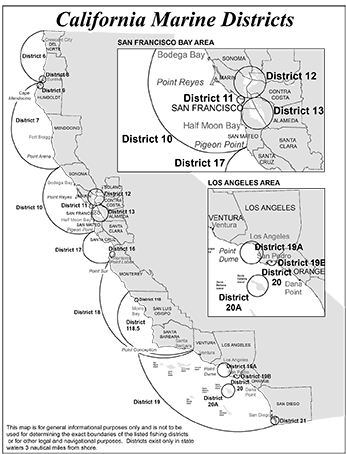
DISTRICT 10 includes the ocean waters of the state and the tidelands lying between the southern boundary of Mendocino County and a line extending west from the Pigeon Point Lighthouse, in San Mateo County, including Tomales Bay to a line drawn from the mouth of an unnamed creek about 1,500 feet north of Tomasini Point to the mouth of unnamed creek at Shell Beach; excluding Bodega Lagoon, all that portion of Bolinas Bay lying inside of Bolinas bar, that portion of San Francisco Bay lying east of a line drawn from Point Bonita to Point Lobos, and all rivers, streams and lagoons.
DISTRICT 11 includes the waters of Golden Gate lying between a line running from Point Bonita to Point Lobos and a line from the foot of Powell Street, San Francisco, to the southerly extremity of Peninsula Point, thence to Northwestern Pacific Railroad ferry slip at Sausalito, thence along shore line to Point Bonita.
DISTRICT 12 includes the waters of Carquinez Straits between San Pablo Bay and Carquinez Bridge; and the waters of San Francisco and San Pablo Bays not included in Districts 11 and 13 and excludes the water lying west of a line drawn from California Point to San Quentin Point, from San Quentin Point to San Pedro Point, from San Pedro Point to the south side of the mouth of Novato Creek and the waters north of a line drawn from the south side of the mouth of Novato Creek directly east to Mare Island.
DISTRICT 13 includes the waters of San Francisco Bay lying south of a line drawn from the Ferry Building to mouth of Oakland Creek or estuary; excluding all streams, sloughs and lagoons.
DISTRICT 16 includes the waters and tidelands to high-water mark of that portion of Monterey Bay lying to the south of a line drawn 100 degrees magnetic from the extreme northerly point of Point Pinos in a straight line easterly to the eastern shore of Monterey Bay.
DISTRICT 17 includes the waters and tidelands to high-water mark of Monterey Bay and the Pacific Ocean, lying between a line extending west from Pigeon Point Lighthouse and a line extending west from Yankee Point, Carmel Highlands in Monterey County, excluding the areas included in District 16, and excluding all rivers, creeks, sloughs and lagoons emptying into the Pacific Ocean and Monterey Bay within the boundaries thus defined.
DISTRICT 18 includes the ocean waters of the state and tidelands to high water mark from Yankee Point of a line extending from the south boundary of Santa Barbara County westerly through Richardson Rock excluding all rivers, streams and lagoons.
DISTRICT 19 includes ocean waters and tidelands from the southern boundary of Santa Barbara County to the southern boundary of the state, and all islands and surrounding state waters (except Districts 19A, 19B, 20, 20A and 21); excluding all rivers, streams, lagoons and bays.
DISTRICT 19A includes ocean waters and tidelands to highwater mark between Malibu Point and Rocky Point (Palos Verdes Pt.), excluding all rivers, streams and lagoons.
DISTRICT 19B includes ocean waters and tidelands northerly of the following line: beginning at the west end of the San Pedro Breakwater, thence in an extended line following the axis of the San Pedro, the middle, and Long Beach breakwaters to the east end of the latter, then to the outer end of the west jetty of Anaheim Bay.