Science Spotlight

rss
  • October 12, 2018

Trail cam photo of black bear in wooded area approaching barbed wire fence
Researchers built 90 hair-snare stations designed to pull a small hair sample from black bears that cross the snares.

Map with legend
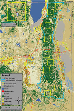
The Warner Mountains Black Bear Project study area (blue boundary) and layout of hair-snare grids (yellow squares) in northeastern California. The upper-left inset shows the southernmost hair snare grid and layout of hair-snare locations (red circles). Density estimates and information on habitat from within the 10 grids will help researchers estimate overall black bear abundance across the entire study area.

California’s black bear population is healthy and growing, with an estimated 35,000 animals, up from an estimated 10,000 to 15,000 in 1982. But how do wildlife biologists determine these figures – and why are they important?

Deep in the Warner Mountains in Lassen and Modoc counties CDFW is just completing the first year of a study of black bears. The lead scientist, Steffen Peterson, explained that anecdotal evidence in recent years – including increased bear sightings by both field scientists and everyday citizens, as well as an increased number of requests for depredation permits due to bear-human conflicts – seemed to indicate that the population of black bears in the Warner Mountains was booming and this area would be ideal for scientific research.

According to Peterson, the two primary objectives of the Warner Mountains Black Bear Project are to estimate black bear abundance in the study area and to determine how black bears use the landscape. This kind of information on black bear demography and space use is essential for wildlife managers to make scientifically sound bear management decisions for this region of California.

CDFW is using a genetic capture-recapture method to estimate the population size. Usually, this involves physically capturing an animal, marking it in some way and releasing it. But this particular study achieves the same goal with non-invasive techniques – specifically by using hair snares, which cause relatively little stress or harm to the animals. Hair snares have been used on many furbearing species to determine presence, to calculate a minimum absolute count of individuals present, or to estimate total population size by collecting a DNA sample from individuals without physically capturing the animal. Unique repetitive sequences, known as microsatellites, within the DNA sample serve as individual identifiers, making it possible to know when and where each unique animal was present.

In addition, because the DNA located within roots of mammalian hair can identify species, sex, and individuality, this genetic technique is ideal for researchers to estimate abundance as well as obtain information on demographics and genetic diversity.

Peterson, a CDFW scientific aid and a Humboldt State University graduate student, and other researchers built 90 hair-snare stations distributed across 10 sampling grids that that are designed to pull a small hair sample from bears that cross the snares.

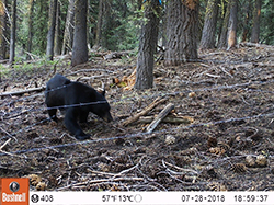
The contraption consists of two parallel strands of barbed wire stretched around a cluster of three or more trees, one about eight inches off the ground and the other about 20 inches off the ground. This forms a barbed-wire “corral” in which researchers place a pile of logs drizzled with fish oil. The oil acts as an attractant to black bears, who have both a finely attuned sense of smell and a profound love of fish. At two thirds of the hair-snare stations, researchers placed a trail-camera to help verify the effectiveness of the snares at capturing hair samples when a bear is present. The trail photos also provide demographic (cub-adult ratio) information on bears within the study area.

“The use of hair-snares to collect genetic data for abundance and density estimates has become the gold standard for American black bear,” said Peterson. “The hope is for the bear to cross between the two strands of barbed wire, although some of our video footage from the trail cameras shows bears crossing – even jumping, in some cases –  over the wire. Because bears are big, robust animals, for the most part they pay little mind to the barbs and typically cross them, leaving us a nice big clump of hair. Bears are the ideal critter for hair-snares in this way.”

Although Peterson stressed that it is much too soon in the study process to draw conclusions about the number of black bears living on the grid, initial results indicate that, at a bare minimum, black bears are certainly roaming throughout the study area.

During a 50-day hair collection period that took place this summer, black bears were detected in all of the grids created in the study area that encompasses roughly 600 square miles of high desert terrain; researchers collected 469 samples of hair in all at 57 of the 90 hair-snare locations.

“Long story short, we are pleased by the amount of detections observed during our data collection,” Peterson said. “Good detections will strengthen our ability to estimate density within each grid which will allow us to more reliably estimate abundance off the grid – i.e., the Warner Mountain study area as a whole.”

Peterson is now set to begin the DNA analysis phase on the samples collected. This will allow him to determine precisely how many individual bears left hair behind (bears often leave more than one sample at a snare location and some individuals are repeat visitors), as well as information on gender and habitat use, including the movement of bears across the study area.

Next summer, project staff will capture and collar 12 adult black bear with research collars, which will record hourly GPS locations of the bears as they move across the landscape, providing information on how they use the landscape, including seasonal habitat preferences and, during the winter hibernation period, where bears den.

“This information will greatly improve our knowledge of how bears use these high desert ecosystems, characteristic of the Great Basin, and guide future land management in this region,” Peterson said.

The project is expected to continue for another two to three years. ###

CDFW Photos. Top Photo: Emily Monfort, a CDFW scientific aid, carefully removes black bear hair from barbed wire at a hair-snare location. The DNA from this clump of hair will be examined in the laboratory to determine the sex and genetic identity of the black bear that crossed this wire.  Photo credit Korrina Domingo (CDFW).

Categories: Wildlife Research
  • February 28, 2018

A trap made of small logs covered with pine and fir fronds is camouflaged in the snow between two tree trunks.
Camouflaged trap used to capture foxes for the study. CDFW photo by Jennifer Carlson.

A bright orange, bushy-tailed fox runs in snow toward dense forest
Sierra Nevada red fox bounds back to its native habitat after capture and study. CDFW photo by Scientific Aide Corrie McFarland.

The Sierra Nevada red fox has been the subject of intensified study by CDFW over the past decade. As they are notoriously tough to track and even tougher to trap, there are many unanswered questions regarding this elusive animal.

In an effort to better understand this state-listed threatened species, an ongoing research project seeks to capture and affix GPS tracking collars to them. The data collected will help biologists better understand the size and characteristics of the fox’s home range, its denning and resting areas, and its foraging habits.

The species has been outfoxing researchers for some time -- to the point where in the 1980s, it was presumed to have vanished forever from its historically occupied habitat in the Cascade and Sierra Nevada ranges. In March 1993, thanks to the then-emerging technology of infrared trail cameras, US Forest Service employees detected a single red fox in the Lassen National Forest.

That discovery prompted a wider study of foxes and other meso-carnivores in and around Lassen Volcanic National Park. In the late 1990s and early 2000s, Dr. John Perrine of the University of California, Berkeley, captured five individuals, primarily in the park, and placed radio collars on them to study their home range (both summer and winter), food habits and resting sites. Unfortunately, two of the collared individuals died within a year and none of the females reproduced during the course of the study.

Years later, CDFW launched a new study to determine the foxes’ current distribution in northern California and to address potential impacts on the species from activities including recreation and timber harvest. Initial efforts in 2008 used scat-detector dogs to survey portions of Lassen Volcanic National Park and the adjacent Caribou Wilderness. Then, from 2009 to 2011, trail cameras and hair-snaring devices were employed to survey high-elevation habitats in the Cascade Range from Mount Shasta to Lassen Peak. Yet foxes were only detected in the Lassen Peak area.

CDFW biologists have continued to survey for foxes with trail cameras, hair-snaring devices and scat surveys. Scats and photos are often obtained along Lassen Volcanic National Park and Forest Service hiking trails, because, like many other animals, red foxes frequent trails as they move through their territories. Analysis of the DNA contained in the collected scats and hair identified 22 individuals from 2007-2016. Some of these foxes are long-lived – samples collected over time from the same individual indicate that five of those individuals lived at least five and a half years.

CDFW efforts to capture and collar Sierra Nevada red foxes since 2013 were unsuccessful – until early February 2018. The nearly two decade-long dry spell came to an end at last when CDFW captured a Sierra Nevada red fox, a male that weighed about 10 pounds. It was captured in a “log cabin” style trap on National Forest land just outside of Lassen Volcanic National Park, near the town of Mineral. The fox was collared and released at the capture location, and CDFW biologists have been impressed by the distances he has regularly been covering since (five to six miles per day) despite the rough terrain and high elevation.

“Persistence played a large role in our success, because there are many days when we do not have any fox detections,” said CDFW Wildlife Biologist Jennifer Carlson. “We also ramped up our efforts this year by hiring two scientific aids rather than just one, which allowed us to literally double our efforts by putting more traps out across the study area.”

CDFW hopes to capture as many as four more red foxes this year. Scientists are using box traps, cage traps and a “log cabin” style trap that researchers have used in other states to capture both red foxes and wolverines. Capturing foxes is not an easy task given the cold temperatures and snowstorms, but as the Lassen population may only consist of around 20 individuals, it is imperative for the department to learn as much as it can about this stealthy animal.

For more information, please visit the Sierra Nevada red fox page.

Top photo: Senior Environmental Scientist Pete Figura and Senior Wildlife Veterinarian Deana Clifford release a red fox study subject. CDFW photo by Corrie McFarland

Categories: General
  • January 26, 2018

For residents of Humboldt and Del Norte counties, the majestic Roosevelt elk is a common sight. Although Roosevelt numbers were dwindling in California by the 1920s, conservative management strategies and limited hunting opportunities have helped them to rebound. Today, researchers have identified more than 20 distinct groups of elk in these two counties, many of which consist of well over 50 animals.

This conservation success story doesn’t come without a downside, though. Elk require large amounts of food to survive, and they tend to graze where food is most plentiful – often in agricultural areas and residential neighborhoods, where they cause damage to crops, landscaping, fencing and other private property.

Partly in response to rising concerns about property damage caused by the Humboldt and Del Norte herds, CDFW scientists are working on a wide-ranging, long-term study of Roosevelt elk population size and growth, herd movements, habitat use, disease and causes of mortality. The project, which is a collaborative effort with researchers from Humboldt State University, will collect critical baseline information about the animals that will help CDFW develop more robust and efficient methods for monitoring the herds, set future hunt quotas, inform local agencies about elk management and manage depredation issues. CDFW initiated this project in 2016 and expects to continue data collection efforts through 2018.

Tracking and studying one of the largest mammals in California is a much more complex undertaking than one might think. Roosevelt elk herds are wide-ranging and tend to graze in areas that are not easily accessible. Traditionally, CDFW relied on aerial surveys to monitor population trends of big game species such as elk, but such surveys are only feasible in a small portion of northwestern California because visibility is limited by steep terrain and dense vegetation. Ground surveys have similar constraints and are further limited by the small amount of occupied habitat that can be easily accessed from roads.

Given these constraints, CDFW scientists are employing multiple survey methodologies for the current study. Different techniques will be used in different habitat types. For example, in hard-to-reach areas, trail camera footage will be compared to visual surveys and used to collect herd composition data and estimate population size. Estimates will also be derived from analyzing the DNA contained in elk droppings.

CDFW also monitors the movement of the Roosevelt elk via electronic collars. There are currently 20 collared elk in coastal Del Norte and northern Humboldt counties and researchers hope to extend this project into central Humboldt County this winter, with plans to collar as many as 30 additional elk. Captured animals are also marked with ear tags, which allow for individual identification.

These survey efforts, and similar efforts elsewhere in the North Coast Roosevelt Elk Management Unit (EMU), are outlined in California’s Draft Elk Conservation and Management Plan, which is available for public review and comment through Monday, January 29. The plan provides guidance and direction to help set priorities for elk management efforts statewide.

CDFW photo: Environmental Scientist Carrington Hilson monitors a Roosevelt elk during a survey of the population.

Categories: General
  • July 25, 2017

Five deer wade knee-deep in blue lake water
cute face of a mule deer

Three people check and attach a collar to a doe
doe on a hillside wears a research collar
Mule deer buck in a dry meadow
Two people collect deer pellets from a trail
Doe and fawn look out from a dry-grassy ridge

As California deer hunters head to the fields, forests and mountains this summer and fall, their experiences will provide wildlife biologists with key data on the health of the state’s deer herds. Wildlife biologists are already seeing the benefits of a 2015 regulation change requiring all deer tag holders to report how they did – successful or not – along with how many days they actually spent hunting, even if they never made it out at all. A record 84 percent of deer tag holders submitted harvest reports for 2016.

“We’re getting more accurate and precise numbers for harvest than we’ve ever had before, which is critical for calculating the tag quota for the next year and conserving our deer populations for the future,” said Stuart Itoga, a senior environmental scientist with CDFW and the state’s deer program coordinator.

Until recently, accurate deer harvest data had proved elusive. Prior to 2015, only successful California deer hunters had to report their take and only about 30 percent of those actually complied. CDFW supplemented the harvest data with numbers collected from game processing facilities, an inefficient process that still left an incomplete picture.

“It’s Wildlife Management 101,” Itoga said. “You have to know what your population is, what’s coming in and what’s going out. We needed to have better numbers.”

Following the mandatory reporting requirement in 2015, submittal rates for deer tag harvest reports jumped to 50 percent. In 2016, a $21.60 non-reporting penalty took effect, which applies to the purchase of future tags, and boosted reporting to the all-time high.

Mandatory deer tag reporting data is just one of a number of new tools that has CDFW deer biologists excited about their ability to better assess California’s deer herds. An innovative DNA study of deer feces promises to give biologists new information about the size and characteristics of the state’s deer population.

CDFW has also greatly expanded the use of deer tracking collars, thanks to improved technology. Since 2016, CDFW has affixed the relatively lightweight, remotely programmable, GPS tracking devices on 350 deer to learn more about their preferred habitat, in-state and out-of-state migration routes and sources of mortality other than hunting. Advanced camera technology also promises to improve the data collected from CDFW’s aerial and ground-based population surveys. A new computer model is being developed to incorporate all of these new data sources into more sophisticated, accurate and precise deer population estimates.

“It’s really an exciting time to be doing this type of work,” Itoga said. “We’ve always used the best available science, but with technology moving at the pace it’s moving now, we have tools available to us now that we didn’t have even five years ago.”

Management changes can happen more quickly as a result. For the upcoming 2017 deer hunting seasons, for example, deer tag quotas were cut in half in three highly desirable, Eastern Sierra X Zones – X9a, X9b and X12 – as a result of new data and field work that showed that migratory deer in these areas suffered from the long, intense winter.

“Winter survival was poor,” Itoga said. “Our hope is that if we reduce the harvest this year, the populations will have a chance to rebound and increase next year.”

Categories: General
  • June 13, 2017

A buck with a collar walks through brush on a hillside
A young woman attaches a trail camera to a dead tree trunk.

Deer population estimates are an important element of the California Department of Fish and Wildlife’s (CDFW) management decisions regarding the species – including setting quotas for deer-hunting seasons, acquiring land and identifying habitat improvement projects. Historically, CDFW has relied upon helicopter surveys to obtain these population estimates, but such surveys can be problematic. While they are effective in open and largely flat areas, they are less so in tree-laden areas where deer are hidden from sight. They can also be extremely expensive.

Now, thanks to emerging DNA technology, scientists are exploring a less invasive, cost-effective alternative: Analysis of what the deer leave behind.

The use of DNA is not new, of course – CDFW has used hair or tissue samples to extract DNA and identify individual animals for years. But scientists are finding that the painstaking collection and analysis of deer droppings is particularly useful because it allows them to gather the necessary information without physically touching (or stressing) the animals. And that, one might say, is the “bottom line.”

Fecal DNA analysis is being used by wildlife biologists in the North Central Region as part of a six-year region-wide study of mule deer (Odocoileus hemionus) that will provide population estimates in areas where data has previously been lacking. CDFW scientists, in cooperation with UC Davis, will use the deer pellets to take a genetic “fingerprint” designed to help estimate deer populations.

Starting in 2016, a crew began setting transects for pellet collection in the standardized sampling locations (known to hunters as deer zones X6a/b, X7a/b and X8) which are located in Lassen, Plumas, Sierra, Nevada, Placer and Alpine counties. After starting points were randomly selected, habitat information and pictures were collected along with fresh pellets. After the pellets were removed from the area in an initial sweep, scientists revisited the transect once a week for three more weeks to collect new samples. Between July and September of 2016, biologists visited 43 different transects in the summer range and collected and analyzed 458 fresh pellet samples. Staff also captured 20 does and seven bucks and fit them with satellite collars that produced data that helped identify summer home ranges.

CDFW will also use DNA to identify individual deer to help gather buck/doe/fawn ratios. Biologists will then combine the DNA data with home range data from collared deer to calculate the estimated number of deer in the population. This year staff have already completed another 36 plots and collared 18 more deer. Another series of pellet collections is scheduled next year, with a goal of continuing until all 17 counties in the region have been sampled.

Although several DNA projects are occurring across the state, this project is the largest landscape-level study for deer in California. The study is funded through CDFW’s Big Game Account, a dedicated account that provides research and management funds for game species. The University of California will conduct the laboratory work and statistical analysis.

Categories: Wildlife Research
CDFW Science Institute logo

Subscribe

Receive Science Institute news by email.